-
You are viewing the forum as a Guest, please login (you can use your Facebook, Twitter, Google or Microsoft account to login) or register using this link: Log in or Sign Up
You are using an out of date browser. It may not display this or other websites correctly.
You should upgrade or use an alternative browser.
You should upgrade or use an alternative browser.
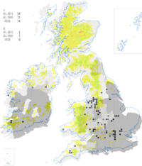
Fissidens UK Soft Water Distribution Map
- Thread starter ZeeDeveel
- Start date

Hi all,
Even in the UK, usually Biological records for bryophytes, most "non charismatic" invertebrates etc. just reflects observational effort, rather than the species actual distribution.
I think that map is from the <"BBS field guide">, which is an excellent resource, but the distribution map will be out of date. I'll have a <"look on INaturalist"> and see what records are on there. I just have and there aren't any records at all.
Cheers Darrel
I've seen it locally, and it is all limestone here, so I'd guess it probably has more to do with where people have looked for it.Thought this might be of interest to some people. After discovering that Fissidens Fontanus is native to the UK I found a map of its distribution, which correlates remarkably with that of the country's soft water distribution.
Even in the UK, usually Biological records for bryophytes, most "non charismatic" invertebrates etc. just reflects observational effort, rather than the species actual distribution.
I think that map is from the <"BBS field guide">, which is an excellent resource, but the distribution map will be out of date. I'll have a <"look on INaturalist"> and see what records are on there. I just have and there aren't any records at all.
Cheers Darrel
Last edited:
Maf 2500
Member
I don't see any correlation on that map between soft water and recorded locations of Fissidens fontanus in any case, the denser clusters are generally in hard or medium water areas.
John q
Member
Definitely not soft water areas. This is a crude example of water hardness in the UK. Light green denotes soft water, the darker the shade denotes harder water.UK I found a map of its distribution, which correlates remarkably with that of the country's soft water distribution.
I think from 2014.but the distribution map will be out of date
I'd agree, compare this map of clusters to the map above. If you overlaid them the vast majority of specimens collected would fall in medium or hard water hardness areas.the denser clusters are generally in hard or medium water areas.
The data Probably correlates to research funding, North South divide and all that.
")
Hi all,
I'd expect a moss associated with soft water would show a much more northern and western distribution, where the older, harder older rocks are.
Cheers Darrel
I still don't get it. It just shows nearly all the sites are in the lowlands.Think you may have misinterpreted my map. It was also a hard water map, the light areas are the soft water. I've overlaid them.
I'd expect a moss associated with soft water would show a much more northern and western distribution, where the older, harder older rocks are.
Cheers Darrel
John q
Member
Lol, I did say the map was crude.Newcastle Upon Tyne has crosssd the Tweed invaded and annexed East Lothian and Berwickshire!